Glaciers of Oregon
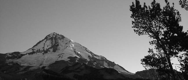 Eliot Glacier, Mount Hood (K.Jackson 2005) |
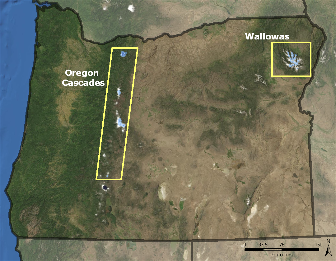
Welcome to the Glaciers of Oregon website. During the Pleistocene era, the entire Oregon Cascades may have been covered by glaciers, forming a small ice cap. Today, however, only remnants of these former times remain. Glaciers are found on the stunning stratovolcanoes of Oregon's Cascade Range and in the rugged and remote Wallowa Mountains of northeastern Oregon. Not only are these glaciers important sources of water to downstream ecosystems and human infrastructure, they are also important shapers of the landscape.
Contents
Glacier Extent
 Blue Marble Imagery |
|
There are more than 450 perennial snow and ice features located in Oregon, covering a total of 43 km2. 60 features are larger than 0.1 km2. Of these, 35 are named glaciers: 12 on Mount Hood, four on Mount Jefferson, seven on South Sister, eight on Middle and North Sisters, two on Broken Top, one on Mount Thielsen (faintly visible because of its small size above), and one in the Wallowas. These regions are examined further below. Note: all statistics here are based on USGS 1:24,000 scale topographic quadrangle maps which were created from mapping photography from dates between 1949 and 1994. The MODIS image displayed above illustrates the areas of higher elevation in Oregon in white (late spring snowpack), while the blue areas are glaciers (these blue features have been added to the MODIS image). The glacier populated areas of Oregon range from 43.1 to 45.5 degrees north and -117.1 to -122.1 degrees west. |
History
Glacial History
|
During the Pleistocene (~1.8 million years BP - 10,000 years BP), the Oregon Cascades may have been covered by glaciers creating a small ice cap (Porter et al., 1983). Scott (1977) inferred maximum glacial extents at Mount Jefferson to have occurred ~20 - 25,000 years ago, which is comparable to those found on Mt. Rainier, Washington. Licciardi et al. (2004) identified two glacial advances in the Wallowas, one at approximately 21,000 years ago and the other at 17,000 years ago. When compared with other glacial maximums from the western United States, the Wallowas illustrate the influence of the Laurentide Ice Sheet on the regional climate. Holocene (~10,000 years ago to the present) glacial fluctuations are better understood in Oregon. Lillquist (1988) identified "Little Ice Age" (a global cool period from about 700 years ago to 150 years ago) moraines on Mount Hood as well as moraines dating to approximately 4,500 - 5,000 years ago. "Little Ice Age" moraines have also been identified on Mount Jefferson (Scott, 1977), the Three Sisters (Marcott, 2005), and Broken Top (Dethier, 1980). Other moraine sets downslope from the "Little Ice Age" moraines on the Three Sisters and Broken Top place glacial advances/stands at about 2,000 - 3,000 and 4,500 - 6,500 years ago. Another moraine set downslope of these pre-dates 7,700 years ago (Marcott, 2005). Kiver (1974) identified "Little Ice Age" moraines in the Wallowas as well as a morainal advance/stand from approximately 2,000 years ago (Prospect Lake). The moraines from the "Little Ice Age" and earlier dates indicate larger glaciers than presently exist. |
Early Exploration
|
Coleman (1878) credits the "discovery" of glaciers in Oregon to Lieutenant-Colonel Gordon Granger, who visited the glaciers of Mount Hood in 1840. However, Arnold Hague's descriptions of Mount Hood's glaciers were the first to be published (King, 1871). In 1867, the U.S. Congress passed legislation funding the War Department to survey all lands east of California along the 40th parallel and named Clarence King the geologist in charge. King sent Hague north from San Francisco in August, 1870. Hague examined the glaciers on the south side of Mt. Hood while climbing to the summit in early September. King is credited with the first "discovery" of glaciers in the American West, during his climb of Shastina (a parasitic volcanic cone on the western flank of Mount Shasta) on September 11, 1870. However, Hague "discovered" the glaciers of Mount Hood at some point between September 4, 1870 and September 18, 1870 (Babson, 1997), and may deserve credit for "discovering" glaciers in the western United States before King. After this expedition, King became the first director of the United States Geological Survey. |
|||
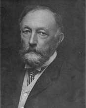 Arnold Hague |
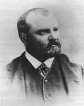 Clarence D. King, 1879 |
||
|
The glaciers of Mount Jefferson were named by Ira A. Williams of the Oregon Bureau of Mines in 1915 (Hatch, 1917). Edwin Hodge (1925) of the University of Oregon studied the glaciers and geology of Mount Jefferson. The glaciers of the Three Sisters region were "discovered" and described by Williams in 1916 (Williams, 1916). Lathrop Glacier on Mount Thielsen was "discovered" by Dr. Theodore Lathrop in 1966. |
|||
|
The Mazamas, an Oregon-based hiking club, began glacier monitoring programs on the glaciers of Oregon's Cascade Mountains in the early twentieth century. A number of aerial surveys were flown during the period of the 1930s to the 1950s (see below). Additionally, select glaciers such as Eliot (Mount Hood) and Collier (North Sister) have been studied extensively by the Mazamas Research Committee and through Mazamas Research Grants. |
|||
Photographs
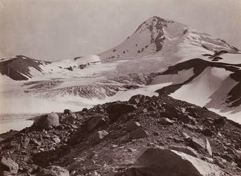 July 23, 1901 photograph of Eliot Glacier (left and center areas of photo), Mount Hood, courtesy Mazamas (H. F. Reid) |
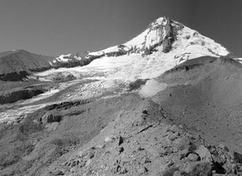 July 22, 2005 repeat photograph of image on left. Note thinning of glacier and exposure of bedrock (K. Jackson) |
||
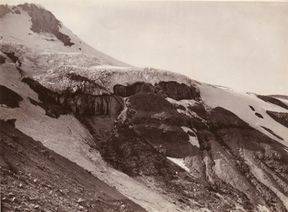
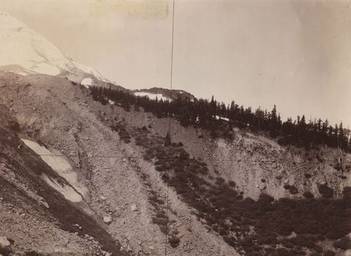 July 23, 1901 photograph of Eliot Glacier's terminus, Mount Hood, courtesy Mazamas (H. F. Reid) |
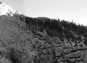 July 22, 2005 repeat photograph of image on left. Note lack of ice on left portion of photo and large increase in vegetation (K. Jackson) |
||
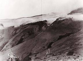
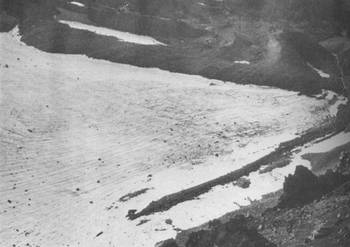
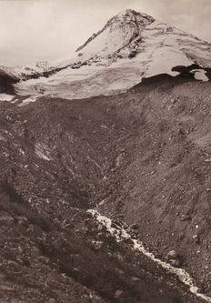 September 15, 1935 photograph of Eliot Glacier's terminus, Mount Hood, courtesy Mazamas (A. J. Gilardi). The terminus is rock-covered and difficult to see (center picture) |
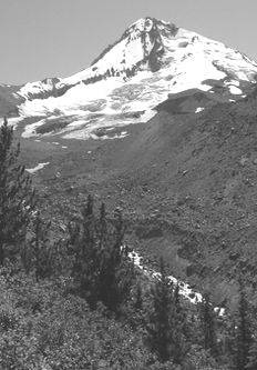 July 22, 2005 repeat photograph of image on left. Note thinning of terminus area as well as exposure of Cooper Spur cliff face left of summit (K. Jackson) |
||
Click HERE for photographs of early activities on Eliot Glacier
Glaciated Regions
| Mount Hood | Mount Jefferson | Three Sisters/Broken Top | Mount Thielsen | Wallowa Mountains |
Mount Hood
|
About 148 snow and ice bodies are found on Mt. Hood, with a minimum elevation of 1295 m, maximum elevation of 3420 m, a mean of 2304 m, and a total area of 22.7 km2. Of these perennial snow and ice features, 12 are named glaciers (all are labeled on the map on the right except Coalman Glacier, located in the crater at the summit) (USGS 1:24,000 scale topographic map, current edition 1996, created from 1956 aerial photographs). Mount Hood is a stratovolcano composed of mostly andesitic rock. The glaciers of the northern side are mantled with rock debris on their termini as a result of frequent rock avalanches from Hood's geothermally altered north face. The glaciers of the southern side are mostly "clean," that is, with little or no rock debris on the ice. |
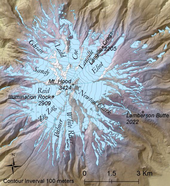 Shaded relief map of Mount Hood. Click on the map above for the full size version. |
|
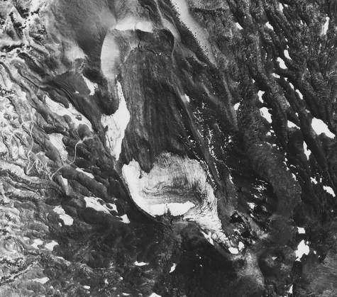
Reid (1905) described Hood's glaciers in detail following a trip to the mountain in 1901. The "White Glacier" (now known as the White River Glacier), Coe, Eliot, and Newton Clark were described and photographed. Reid noted that the three northern glaciers (Ladd, Coe, and Eliot) were covered by debris as opposed to those on the south side of the mountain. Eliot Glacier, named after Dr. Thomas Eliot of Portland, Oregon, has been the most studied glacier on Mt. Hood. For more information about the glacier, click HERE. |
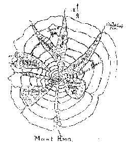 Map of Hood created by W.A. Langille, circa 1900. (Reid, 1905) |
 White River Glacier, 1901 (H.F. Reid) |
|
 Coe Glacier, 1901.(H.F. Reid) |
 Newton Clark Glacier, 1901 (H.F. Reid) |
Back to Glaciated Regions
Back to Contents
Mount Jefferson
|
About 35 perennial snow and ice features are found on Mt. Jefferson with a minimum elevation of 1877 m and a maximum elevation of 2496 m. Mean elevation is 2496 m and the total area is 5.5 km2. Of these snow and ice bodies, four are named glaciers (all are labeled on the map on the right) (USGS 1:24,000 scale topographic map, current edition 1997, created from 1949 aerial photographs). The glaciers of Mt. Jefferson are mostly confined to the north, east, and southeast slopes of the mountain. However, in the early twentieth century a glacier was described occupying the western flank of the mountain and was named "Milk Creek Glacier" (Milk Creek is the area under the "Mt. Jefferson" label on the map on the right). However, as Hatch (1917) stated, it was merely a glacial remnant of "stagnant ice" partially covered in debris. The current glacier coverage delineated on USGS 1:24,000 scale quadrangle maps (see figure at right) do not label this feature. As early as 1917, Hatch noted that Russell and Jefferson Park glaciers (along with the rest of the mountain) had undergone a recent retreat leaving behind well-defined lateral moraines. Hatch described Whitewater Glacier as approximately five miles wide and one to two miles long splitting into five lobes. Currently, however, Whitewater Glacier is only about three kilometers (1.9 miles) wide and just over one kilometer long. |
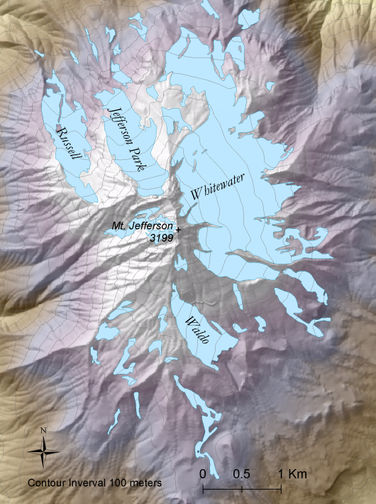 Shaded relief map of Mount Jefferson. Click on map for a full sized version. |
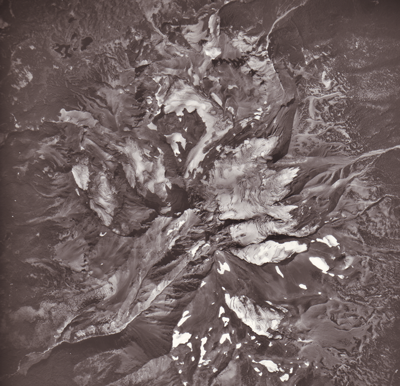 Aerial image of Mount Jefferson, 1979. (USGS)
|
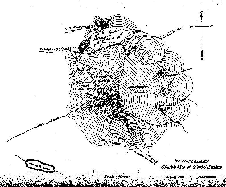 August, 1917 map of Mount Jefferson created by R.J. Davidson (Hatch, 1917) |
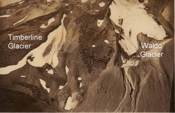
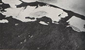
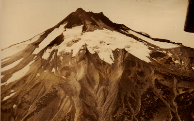 1937 oblique aerial photograph of Whitewater Glacier (center) and Waldo Glacier (far left), looking west, courtesy of Mazamas (A.J. Gilardi) |
|
Back to Glaciated Regions
Back to Contents
Three Sisters/Broken Top Region
North/Middle Sisters |
|
|
About 78 perennial snow and ice features are found on North and Middle Sisters with a minimum elevation of 2055 m and a maximum elevation of 3063 m. They have a mean elevation of 2490 m and a mean area of 5.4 km2. Of these snow and ice bodies, eight are named glaciers and are all labeled on the map on the right (USGS 1:24,000 scale topographic map, current edition 1997, created from 1957 aerial photographs). |
 Shaded relief map of the North/Middle Sisters. Click on the map above for the full size version. |
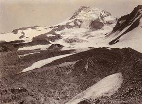
 Middle and North Sisters, 2004 (S. Marcott) |
|
|
Williams (1916) described four active glaciers on Middle Sister: Hayden, Diller, Renfrew, and Collier. Of these, Collier Glacier has been studied in detail. When Williams examined Collier in 1916, he declared Collier was as large, if not larger, than the other glaciers of the Oregon Cascades. In 1910, the terminus of Collier Glacier reached Collier Cone. Since 1910, however, Collier has retreated almost two kilometers and lost over one square kilometer of its area. |
|
South Sister |
|
|
About 51 perennial snow and ice features are found on South Sister with a minimum elevation of 2205 m and a maximum elevation of 3142 m. Their mean elevation is 2588 m and total area is 4.4 km2. Of these snow and ice bodies, seven are named glaciers (all are labeled on the map on the right) (USGS 1:24,000 scale topographic map, current edition 1997, created from 1957 aerial photographs). The earliest descriptions of past and present glaciations in the Three Sisters were made in 1916 by Ira Williams of the Oregon Bureau of Mines and Geology (Williams, 1916). Williams described that "Lost Creek canyon throughout practically its entire length from where it heads against the slopes of South Sister to its union with the McKenzie, a distance of twenty miles or thereabouts, is deeply glacier cut and its U-shaped cross section is not to be mistaken" (Williams, p. 15). Five glaciers were described on the slopes of South Sister (currently there are 7 named glaciers), all noted to be much smaller than in recent historic times. Many of these glaciers were and still are mantled with rock debris on their lower margins. |
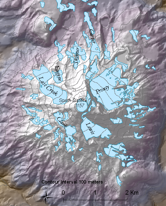 Shaded relief map of the South Sister. Click on the map above for the full size version. |
|
Williams described (and named) Prouty Glacier as breaking into four fingers of ice, each terminating into a small lake of glacially discharged water. Lewis Glacier was described as splitting into two lobes, the eastern of which ended abruptly in a 40 to 50 ft high ice face which often calved sending large ice blocks down the steep slope the glacier mantled. |
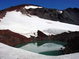 Lewis Glacier and moraine-dammed lake, 2004 (M. Weaver)
|
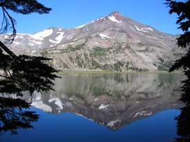 South Sister and Green Lake, 2004 (S. Marcott) |
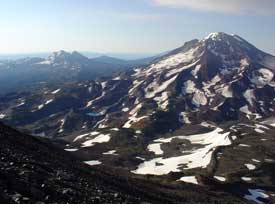 South Sister (right) and Broken Top (left) from Middle Sister, 2005 (M.Weaver) |
 Unnamed perennial ice feature in the summit crater of South Sister, 2004 (M.Weaver) |
|
Broken Top |
|
|
About 33 perennial snow and ice features are found on Broken Top with a minimum elevation of 2152 m, a maximum elevation of 2736 m, a mean of 2382 m and a toal area of 3.3 km2. Of these snow and ice bodies, two are named glaciers (both are labeled on the map on the right) (USGS 1:24,000 scale topographic map, current edition 1997, created from 1957 aerial photographs). Many of the snow and ice bodies on Broken Top exist as a result of topographic shading as these bodies exist at a lower elevation than do those on the nearby Three Sisters. |
 Shaded relief map of Broken Top. Click on the map above for the full size version. |
 Broken Top and Bend Glacier, 2005 (M. Weaver) |
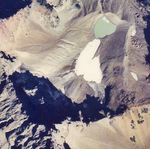
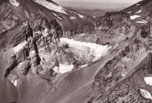
 Glacier and moraine-dammed lake to the east of Broken Top summit,1938 (K.N. Phillips, 1938) |
Back to Glaciated Regions
Back to Contents
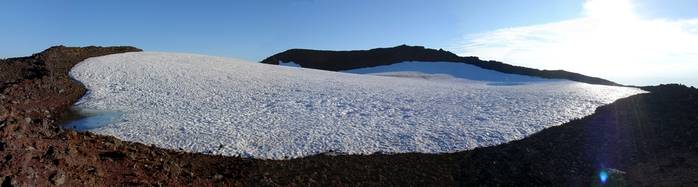
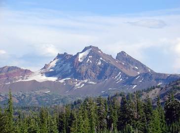
Mount Thielsen
|
One ice body (two lobes that are grouped as one glacier, Lathrop) is found on Mt. Thielsen and ranges in elevation from 2498 m to 2601 m, with a mean of 2565 m and an area of 0.003 km2 (USGS 1:24,000 scale topographic map, current edition 1998, created from 1994 aerial photographs). |
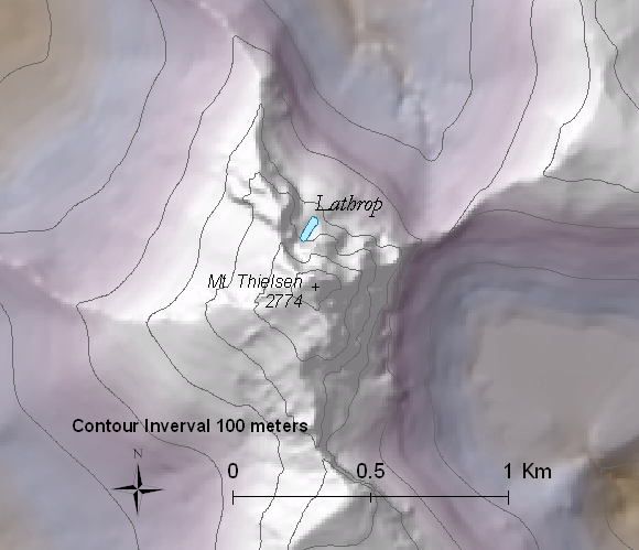 Shaded relief map of Mount Thielsen. Click on the map above for the full size version. |
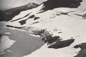
 Lathrop Glacier, 1998 (R. Nafziger) Note how the glacier is shaded, helping to preserve the ice |
|
|
Mount Thielsen essentially is a geomorphic feature called a horn. This is a glacially-modified peak, the most famous of which is the Matterhorn. Four cirques surround the mountain almost perfectly leaving four aretes and a horn, a classic example of glacial erosion. Lathrop Glacier was "discovered" in 1966 when Dr. Theodore Lathrop peered from the summit down the north face of Mt. Thielsen and thought the two small snow and ice bodies he saw might be an active glacier. Starting in 1968, Dr. Lathrop's nephew, Ralph Nafziger and others began monitoring Lathrop Glacier's east and west lobes with photographs after repeated attempts at placing stakes in the glacier surface failed. Lathrop Glacier lies in a shady northeastern slot and is the last remaining glacier on Thielsen and the southernmost glacier in Oregon. Click HERE for a photographic record of Lathrop Glacier, donated by Ralph Nafziger of Albany, Oregon. |
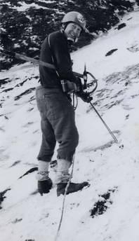 Dr. Theodore Lathrop on Lathrop |
Back to Glaciated Regions
Back to Contents
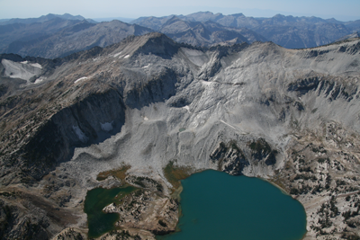
Wallowa Mountains
|
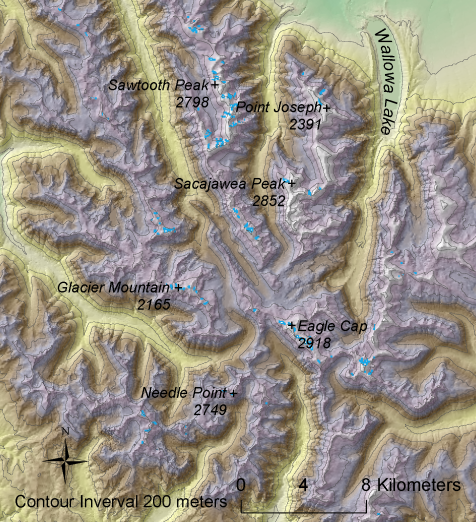
About 131 perennial snow and ice features are found in the Wallowa Mountains with a minimum elevation of 2297 m, a maximum elevation of 2898 m, a mean of 2688 m, and a total area of 1.5 km2. Of these snow and ice bodies, only one, the Benson Glacier, is a named glacier (USGS 1:24,000 scale topographic maps, current edition 1990, created from 1981 aerial photographs). The Wallowas were once heavily glaciated, as displayed by large U-shaped glacial valleys as well as cirques (a bowl-shaped depression resulting from glacial erosion). Wallowa Lake is a moraine-dammed lake; the moraines were formed during the last ice age. However, it is highly unlikely that any of the blue areas identified on this map are more than perennial snowfields. Benson Glacier (below), named for Frank W. Benson, an early governor of Oregon, is located on Eagle Cap (see figure at right), and may still be an active glacier. |
 Shaded relief map of the Wallowas. Click on the map above for the full size version. |
 Repeat photograph of Benson Glacier (Skovlin et al., 2001) |
 Benson Glacier. September 2007. John Scurlock |
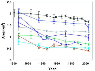
Glacier Change
| These graphs display the spatial losses of six of Mount Hood's glaciers and Collier Glacier, North Sister. The upper graph presents total areal losses of the glaciers in square kilometers and the lower graph normalizes this data with each glacier's original area set at 100%. | |
 |
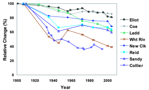 |
| (Jackson and Fountain, 2007) | |
Vanished Glaciers???
| The following Oregon glaciers may have disappeared since their initial "discoveries" around 1900 (photos courtesy Mazamas) | |
Sholes Glacier:Located on Mount McLoughlin, about 85 km south of Mount Thielsen, was "discovered" in 1896, but by 1939 it had vanished (Phillips, 1939). |
 Sholes Glacier: left image from 1896 (B.W. Evermann), right image from 1939 (K.N. Phillips) |
Timberline Glacier:
Located on Mount Jefferson, Timberline Glacier was photographed (right) and described by Phillips (1938) but no longer is shown or labeled on maps. |
 Timberline Glacier, 1937 (A.J. Gilardi) |
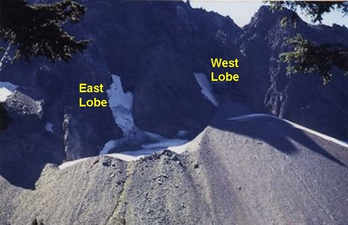
Milk Creek Glacier:
Located on Mount Jefferson, Milk Creek Glacier occupied the western slope of the mountain (two adjacent lobes) when first explored by Williams in 1916 (Hatch, 1917), but by 1938 (below) was merely a glacial remnant and currently is not labeled on United States Geological Survey 1:24,000 scale topographic maps. |
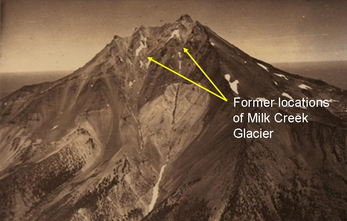 Milk Creek Canyons, 1937 (A.J. Gilardi) |
 Glacial remnant of Milk Creek Glacier, 1938 (K.N.Phillips) |
|
Jack Glacier:Located on Three Fingered Jack and described by Phillips (1938), Jack Glacier is no longer labeled on United States Geological Survey maps and may no longer exist. However, this aerial photograph from September 14, 1990 (below) displays remaining patches of ice, and its extremely well-protected location limits solar radiation and may be the ideal location for a glacier to remain. |
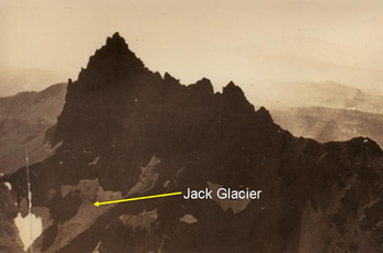 Jack Glacier, 1937 (A.J. Gilardi) |
 Jack Glacier, 1990 (USFS) |
|
Crater Glacier:
Located on Broken Top, Crater Glacier is actually mistakenly labeled as Crook Glacier on the 1:24,000 scale United States Geological Survey topographic quadrangle maps. Phillips (1938) identified Crater Glacier as well as nearby Crook Glacier (several hundred meters to the east) but when the topographic maps were created in 1957, Crater Glacier was labeled Crook Glacier and Crook Glacier received no name. Crater Glacier was smaller and less protected from solar radiation and has possibly disappeared since the 1966 oblique aerial photograph below. |
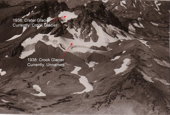 Broken Top, looking northwest, 1956 (H. Ackroyd) |
 September 22, 1966 (A. Post) |
|
Dutchman Glacier:
Located on Bachelor Butte, in the early 1920's Dutchman Glacier extended down to a moraine-dammed lake, but by 1938 had retreated to what most likely was a stagnant body of ice with no crevasses (Phillips, 1938). Current United States Geological Survey topographic quadrangle maps do not show any remaining perennial snow or ice on Bachelor Butte. However, in 1967, an ice body still remained (below) and may still persist. |
 Dutchman Glacier, 1938 (K.N. Phillips) |
 September 19, 1967 (A. Post) |
|
Diamond Glacier:
Located on Diamond Peak, Diamond Glacier was "discovered" in 1938 by Harry L. Clark and Kenneth N. Phillips (Phillips, 1938). This was the southernmost glacier in Oregon, but currently is most likely no longer present. Current United States Geological topographic quadrangle maps do not show the glacier. |
 Diamond Glacier, 1938 (K.N. Phillips) |
Comparison Photos
|
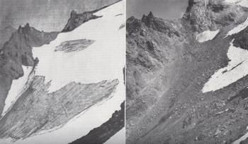
Collier Glacier in 1937 (left, from Mazamas) and 2007 (right, photo by John Scurlock) |
|
|
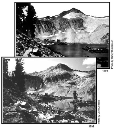
Benson Glacier in 1920 (left, from USGS) and in 1992 (right, Photo by D. Jensen) |
|


Fun Facts
|
|
|
 |
Links
| Glaciers of the American West Portland State University Glacier Research Keith Jackson's Eliot Glacier research |
References
|
Babson, S. G., 1997, Letters from Arnold Hague: early Mount Hood explorer, Volume 98, Oregon Historical Quarterly, p. 206-221. Coleman, E. T., 1878, Mountains and mountaineering in the Far West: The Alpine Journal, v. 8, no. 59, p. 385-398 Dethier, D. P., 1980, Reconnaissance study of Holocene glacier fluctuations in the Three Sisters area, Oregon: Eos Transactions American Geophysical Union, v. 61, no. 6, p. 69. Grauer, J., 1975, Mount Hood: A Complete History. Self-Published, 296 p. Hatch, L., 1917, The glaciers of Mount Jefferson [Oregon]: Mazama, v. 5, no. 2, p. 136-139. Hodge, E. T., 1925, The geology of Mt. Jefferson: Mazama, v. 7, no. 2, p. 25-28. Iddings, J. P., 1919, Biographical memoir of Arnold Hague, 1840-1917. Biographical Memoirs, Kessinger Printing. 24 p. Jackson, K. M., and Fountain, A. G., 2007, Spatial and morphological change on Eliot Glacier, Mount Hood, Oregon, USA: Annals of Glaciology, v. 46, p. 222-226. King, C., 1871, Active Glaciers within the United States: Atlantic Monthly, v. 27, p. 371-377. Kiver, E. P., 1974, Holocene glaciation in the Wallowa Mountains, Oregon, in Geographical Monographs. York University Quaternary Environments, Toronto, Canada. p. 169-196. Licciardi, J. M., Clark, P. U., Brook, E. J., Elmore, D., and Sharma, P., 2004, Variable responses of western US glaciers during the last deglaciation: Geology, v. 32, no. 1, p. 81-84. Lillquist, K. D., 1988, Holocene fluctuations of the Coe Glacier, Mount Hood, Oregon. M.S. Geology, Portland State University. Marcott, S. A., 2005, A tale of Three Sisters: reconstructing the Holocene glacial history and paleoclimate record at Three Sisters Volcanoes, Oregon, United States. M.S. Geology, Portland State University. McNeil, F. H., 1937, Wy'east, "The mountain"; a chronicle of mount Hood known to the Indians, who worshipped it, as Wy'east; to the white man, with equal eloquence, simply as "The Mountain". Metropolitan Press, Portland, OR. 244 p. Nelson, L. A., 1924, A new glacier on Mt. Hood: Mazama, v. 6, p. 67-70. Phillips, K. N., 1938, Our vanishing glaciers; observations by Mazama research committee on glaciers of the Cascade Range in Oregon: Mazama, v. 20, no. 12, p. 24-41. -, 1939, Farewell to Sholes Glacier: Mazama, v. 21, p. 37-40. Porter, S. C., Pierce, K. L., and Hamilton, T. D., 1983, Late Wisconsin Mountain Glaciation in the Western United States, in Late-Quaternary Environments of the United States, Volume 1: University of Minnesota Press, Minneapolis, MN p. 71-111. Reid, H. F., 1905, The glaciers of Mt. Hood and Mt. Adams: Mazama, v. 2, no. 4, p. 194-200. Scott, W. E., 1977, Quaternary Glaciation and Volcanism, Metolius River area, Oregon: Geological Society of America Bulletin, v. 88, no. 1, p. 113-124. Skovlin, J. M., 2000, Interpreting landscape change in high mountains of northeastern Oregon from long-term repeat photography: Portland, Or., U.S. Dept. of Agriculture, Forest Service, Pacific Northwest Research Station. Williams, I. A., 1916, Glaciers of the Three Sisters [Oregon]: Mazama, v. 5, no. 1, p. 14-23. |
Created by Keith Jackson: 06.06.05
Last modified: 22 June 2011