Glaciers of Colorado
|
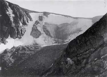
Tyndall Glacier 1916 (Herbert T. Cowling) |
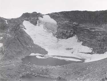
Sprague Glacier 1956 (Norman B. Herkenham; from NSIDC) |
Welcome to the Glaciers of Colorado webpage. During the Pleistocene era, valley glaciers covered many Colorado mountain ranges, and there were even a few small ice caps. Today, however, only tiny remnants of these former glaciers remain. Small glaciers, permanent icefields and permanent snowfields are found primarily in northern Colorado, but ranges from across the state are represented.
|
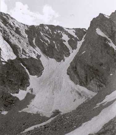
Rowe Glacier 1930 (J. McLaughlin; from Rocky Mountain National Park Archives) |
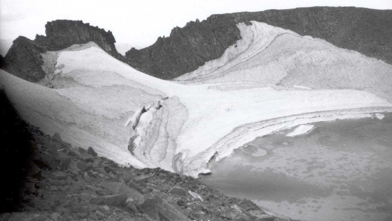
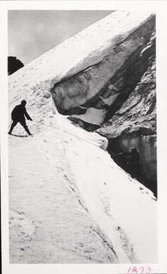
Taylor Glacier, 1956 (Norman B. Herkenham; from Rocky Mountain National Park Archives) |
Contents
Glacier Extent
 Blue Marble Imagery |
|
There are more than 135 permanent snow or ice bodies mapped in Colorado, but only 7 of these are larger than 0.1 km2. Colorado has 14 named glaciers - all in the Front Range, most significantly in Rocky Mountain National Park. The total area of all the mapped snow and ice bodies in Colorado is about 4.8 km2. The seven regions containing Colorado’s glaciers are examined further below. Note: all statistics here are based on USGS 1:24,000 scale topographic quadrangle maps which are based on mapping photography ranging from 1952 to 1985. The MODIS image displayed on the right illustrates the areas of higher elevation in Colorado in white (late spring snowpack), while the blue areas are glaciers (these blue features have been added to the MODIS image). The glaciated areas of Colorado include all the white areas and locally significant portions of the green forested areas. Most glaciers and snowfields in Colorado occur in east- to north-facing cirques at high elevations near the ridge crests. These locations favor snow accumulation from avalanches and windblown snow in the winter, and are well-shaded from summer sun. It is highly unlikely that any of Colorado's glaciers could exist today without the benefit of these local topographic effects. Many of the features appear to feed rock glaciers, and the area of debris-covered ice in the state may be significantly larger than that of exposed clean ice. |
Glacial History
|
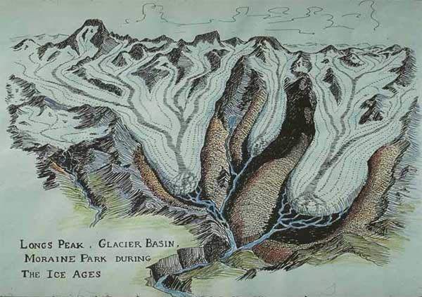
According to Madole (1976), during the latter part of the Pleistocene (~1.8 million years before present - 10,000 years BP) and into the early Holocene (10,000 years BP - present) large valley glaciers were present across most of the higher mountain ranges of Colorado, and a small icecap formed in the northwest part of Rocky Mountain National Park. Valley glaciers in the Front Range were typically 15-25 km long and 1-3 km wide, reaching down to elevations of 2440 to 2745 m. These valley glaciers ranged in thickness from 215 to 460 m. The longest was 45 km long, located in the valley of the Cache la Poudre River and fed by the icecap. In Colorado, only two Pleistocene glacial advances are recorded on the landscape: Bull Lake and Pinedale (The names come from the Wind River Range where these glacial advances were first identified). The Bull Lake glaciation is thought to have occurred 125,000 to 50,000 years BP, while the Pinedale glaciation has been dated to 29,000 to 7,600 years BP. Generally the Bull Lake glaciation was more extensive. Additionally, there have been three small Holocene glacial advances termed, from oldest to youngest, Triple Lakes, Audubon, and Arapaho Peak. Collectively these minor advances are termed Neoglaciation, and the largest glacier during these advances was only 1.6 km long. The Arapaho Peak advance is local evidence for the Little Ice Age (the popular name for a period of cooling in the northern hemisphere lasting approximately from the 14th to the mid-19th centuries). Most of the glaciers and perennial ice patches in Colorado today are the tattered remnants of these small Little Ice Age glaciers.
|
Early Exploration
|
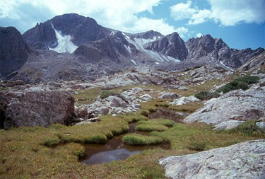
It was not until late in the 19th century that the presence of glaciers, past or present, in Colorado was recognized. (It is unknown if Native Americans had identified the presence of glaciers in Colorado, but the Ute Indians did made extensive use of high passes in the Rockies (Buchholtz, 1983).) In fact, Mary Dartt (1879), Israel Russell (1885), and Theo Comstock (1886) all made emphatic statements that no glaciers exist in Colorado (Henderson, 1910). Clarence King identified Colorado as having been formerly glaciated, but neither he nor Ferdinand Vandeveer Hayden identified any glaciers in Colorado in their USGS surveys of the American West (Henderson, 1910). The first scientific description of a glacier in Colorado belongs to G.S. Stone of Colorado Springs who described Hallett Glacier (now known as Rowe Glacier) in northern Rocky Mountain National Park in the journal Science in 1887: However, according to the National Park Service, Israel Rowe first discovered the glacier while bear hunting in 1880. The Park Service renamed the glacier after Rowe in 1932 to avoid confusion with Hallett Peak 15 miles south (near Tyndall Glacier). The first decade of the twentieth century saw an increase in the awareness of glaciers in Colorado. W.T. Lee first described Arapaho Glacier (Colorado's largest) in 1900 in the journal Science. Enos Mills (considered the Father of Rocky Mountain National Park) wrote a guidebook in 1905 that included a map locating Andrews, Hallett, Sprague, and Tyndall glaciers. Isabelle Glacier was discovered by Fred A. Fair in 1908 (Henderson, 1910). Henderson named Fair Glacier after him, which he also discovered. Tyndall Glacier had been identified by 1893 (by Frederick H. Chapin) and Sprague Glacier by 1895 (by Enos Mills). Outside of the Front Range, ice masses or glaciers were described on the northeast side of Blanca Peak in the Sangre de Cristo Range, (Siebenthal, 1907) and in various places in the San Juan Mountains (Hills, 1884). Interestingly, none of these features are present on the USGS topographic maps of the 1950s. |
|||
|
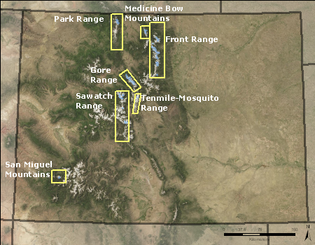
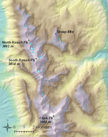
Glaciated Regions
Eight areas contain or have historically contained glaciers and/or permanent snowfields in Colorado:
Front Range |
Medicine Bow Mountains |
Park Range |
Tenmile Range |
Sawatch Range |
San Miguel Mountains |
Sierra Blanca |
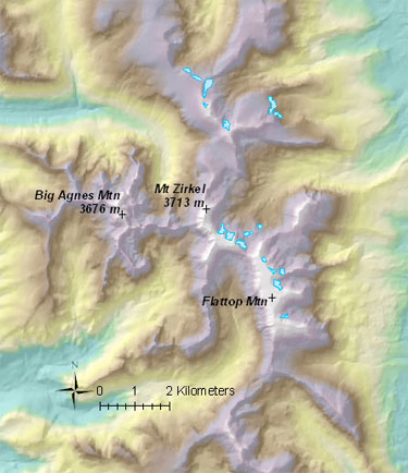
Front Range
|
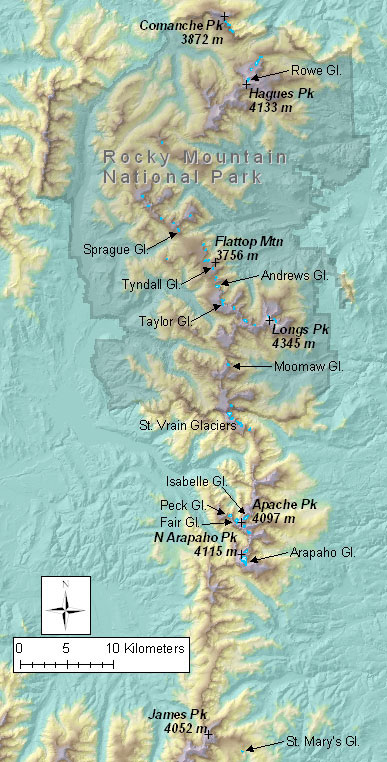
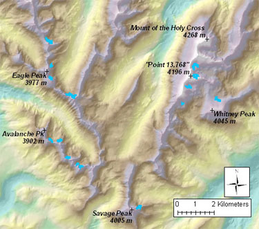
48 snow and ice bodies are found in the Front Range with a minimum elevation of 3294 m and maximum elevation of 4068 m. Their mean elevation is 3671 m, and total area is 2.1 km2. The Front Range contains all of Colorado's 14 officially named glaciers (including Arapaho and Rowe glaciers pictured above). The largest glacier in Colorado is Arapaho Glacier (0.24 km2), located in the central Front Range. The Front Range has 11 of the state's 26 glaciers larger than 0.05 km2, and five of the ten largest. It is the only place in Colorado where glaciers have been studied, and to many glaciologists, the only place in the state with true glaciers. Rocky Mountain National Park contains 32 of the Front Range snow and ice features, including 8 of the named glaciers. The rest are in or near the Indian Peaks Wilderness. The tiny St. Mary's Glacier is located southeast of James Peak near I-70. (Glacier outlines in Front Range from USGS 1:24,000 scale topographic maps, created from 1951-1958 aerial photographs) Most of the glaciers and snowfields of the Front Range occur in cirques on the east side of ridges - only 3 features are on the west side of the Continental Divide, all of which are in protected north to east facing cirques. Interestingly, there are also a number of icefields on relatively flat ridge tops. |
|||
|
Back to Glaciated Regions of Colorado
Back to Contents
Medicine Bow Mountains
|
About 10 snow and ice bodies are found in the Medicine Bow Mountains with a minimum elevation of 3384 m, maximum elevation of 3793 m, a mean elevation of 3564 m, and a total area of 0.17 km2. There are no named features, and the largest feature is 0.04 km2. These features were mapped by the USGS from photos taken in 1958. (Glacier outlines in Medicine Bow Mountains from USGS 1:24,000 scale topographic maps, created from 1958 aerial photographs). The glaciers and snowfields of the Medicine Bow Mountains all occur in east-facing cirques near the ridge crest, like most glaciers and snowfields in the state. Presumably all of these features are permanent snowfields or stagnant ice and no active glaciers exist in the Medicine Bow Mountains. However, 9 of the mapped features contain ice on September 13, 1999, USGS air photos, and the feature above Rockhole Lake shows what may be a small crevasse (see lower right). Most features have shown either a modest decrease or little change in area from 1958 to 1999. The two features in the figure below are typical. Many of the features seem to feed rock glaciers as seen in the image below. |
 Glaciers and snowfields in the Medicine Bow Range shown in blue |
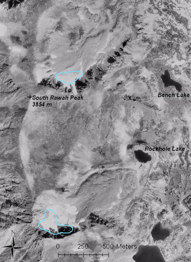 Two of the larger 1958 mapped ice features in the Medicine Bow Mountains are shown in blue outline on this air photo. Extensive rock glaciers can be seen flowing out of these features. (Photo: USGS, September 13, 1999)
|
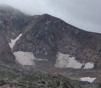 Snow/ice feature typical of the Medicine Bow Range. This feature is located in the north cirque of Clark Peak and was not mapped by the USGS. |
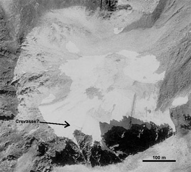 Air photo of possible crevasse on ice feature above Rockhole Lake (Photo: USGS, September 13, 1999) |
Back to Glaciated Regions of Colorado
Back to Contents
Park Range
|
About 18 snow and ice bodies are found in the Park Range with a minimum elevation of 3256 m, a maximum elevation of 3647 m, with a mean of 3462 m and a total area of 0.49 km2. There are no named features, and the largest feature is 0.06 km2. These features were mapped by the USGS from photos taken in 1952. (Glacier outlines in Park Range from USGS 1:24,000 scale topographic maps, created from 1952 aerial photographs) The glaciers and snowfields of the Park Range all occur in east- to north-facing cirques near the ridge crest. Presumably all of these features are permanent snowfields or stagnant ice and no glaciers exist. However, most of the mapped features contain ice on 9/13/1999 USGS air photos, and have shown only a modest decrease in area from 1952 to 1999. No crevasses are visible on the September 13, 1999, USGS air photos. Many of the features seem to feed rock glaciers. The Park Range receives some of the highest annual precipitation in the state 2003 (Daly et al., 2003).
|
Back to Glaciated Regions of Colorado
Back to Contents
Gore Range
|
About 35 snow and ice bodies are found in the Gore Range with a minimum elevation of 3388 m, a maximum elevation of 4013 m, a mean elevation of 3710 m, and a total area of 1.49 km2. There are no named features, and the largest feature is 0.20 km2. There are 11 features larger than 0.05 km2. These features were mapped by the USGS from photos taken in 1969 or 1975, depending on location. (Glacier outlines in Gore Range from USGS 1:24,000 scale topographic maps, created from 1969-1975 aerial photographs) The glaciers and snowfields of the Gore Range generally occur in east- to north-facing cirques on the east side of the ridge crest. Presumably most of these features are permanent snowfields or stagnant ice and few, if any, active glaciers exist. However, most of the mapped features contain ice on October 12, 1999, USGS air photos, and have shown only a modest decrease in area from 1969 or 1975 to 1999. No crevasses are visible on the October 12, 1999, USGS air photos, but early season snow covers most ice features. Some of the features seem to feed rock glaciers, and there are extensive rock glaciers found in the Gore Range. The northern Gore Range has more and larger glacier/snowfield features while the southern Gore Range has more and larger rock glaciers. |
|
 Two ice features on north face of Mount Powell |
 Three ice features on north face of Mount Powell |
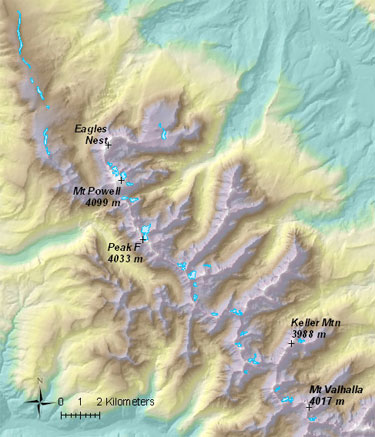 Glaciers and snowfields of the Gore Range |
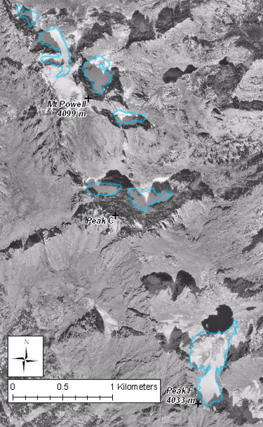 Typical glacier/snowfield change in the Gore Range. Outlines are original USGS mapping (lower feature mapped from 1969 photo, rest of features from 1975). Aerial photo was taken October 12, 1999. Note that early season snowfall has obscured the edges of the ice features. |
Back to Glaciated Regions of Colorado
Back to Contents
Tenmile Range
|
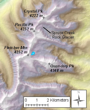
Only one snow/ice body is found in the Tenmile Range. It has a minimum elevation of 3896 m and a maximum elevation of 4015 m, with a mean of 3959 m, and an area of 0.03 km2. This feature was mapped by the USGS from photos taken in 1968. Air photos of the feature dated 9/9/1999 and 10/12/1999 show little evidence of any ice, but there may be a small rock glacier in its place. (Glacier outline in Tenmile Range from USGS 1:24,000 scale topographic maps, created from 1968 aerial photographs) The Tenmile Range contains numerous rock glaciers. The Spruce Creek Rock Glacier, one valley north, is one of the more dramatic examples of a rock glacier in Colorado. It has been studied extensively by Eric Leonard at Colorado College. |
 Single mapped icefield in Tenmile/Mosquito Range |
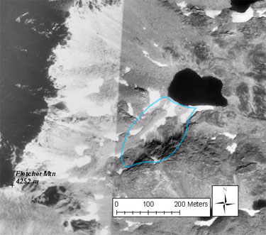 1968 outline of single Tenmile Range feature in blue. Air photo is USGS September 9, 1999, and October 12, 1999. |
 Air photo of Spruce Creek Rock Glacier (courtesy of USDA-Forest Service and Eric Leonard) |
Back to Glaciated Regions of Colorado
Back to Contents
Sawatch Range
|
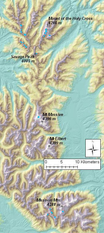
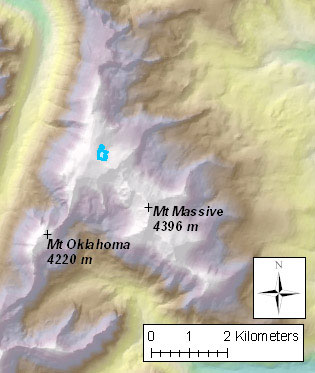
About 25 snow/ice bodies are found in three areas of the Sawatch Range. Elevation ranges from 3293 m to 4290 m, with a mean of 3811 m, and a total area of 0.35 km2. There are no named features, and the only feature larger than 0.05 km2 is located on Mount Massive (0.52 km2). These features were mapped by the USGS from photos taken in 1964, 1968, or 1975, depending on location. (Glacier outlines in Sawatch Range from USGS 1:24,000 scale topographic maps, created from 1964-1975 aerial photographs) The features of the Sawatch Range tend to be very small and located in southeast to northeast facing cirques near ridge crests. |
 Glaciers and snowfields in the Sawatch Range shown in blue |
|
The 19 features in the Holy Cross Wilderness are generally small, isolated ice patches or ice that feeds rock glaciers. Most have shrunk in size from 1968 to 1999, but still show ice. The large feature in the photo below is the largest in the area and has maintained its size. The features in the Holy Cross are similar to those in the nearby Gore Range. |
|
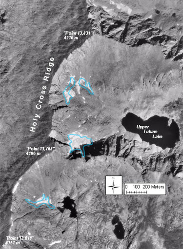 Icefields on Holy Cross Ridge. Blue outline is from 1968 topo map. Air photo is USGS October 12, 1999. Ground photos show green tint to Upper Tuhare Lake and lake at lower left of photo, suggesting the presence of glacial flour. |
 Glaciers and snowfields in the northern Sawatch Range (Holy Cross Wilderness) shown in blue |
|
The single feature on Mount Massive is the largest in the Sawatch Range. The aerial photo below indicates it is an ice feature and has grown between 1965 and 1999. This feature is somewhat unique in that it exists on a relatively flat ridge top with very little topographic shading. It shows no evidence of movement, so it would not be classified as a glacier. |
|
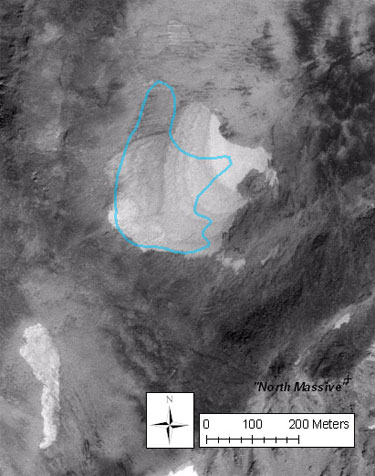 Icefield on Mount Massive. Blue outline is from 1964 topo map. Air photo is USGS October 12, 1999. |
 Glacier or snowfield in the central Sawatch Range (Mount Massive Wilderness) shown in blue |
|
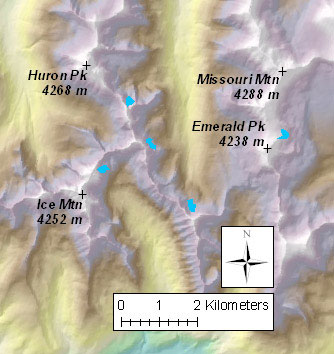
The 5 features in the Collegiate Peaks Wilderness are all very small. Based on 1999 air photos all of them have all but disappeared since 1975. However, this region shows a particularly high density of rock glaciers (see photo below). |
|
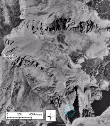 Icefield on Huron Peak. Blue outline is from 1975 topo map. Air photo is USGS, October 12, 1999. Note that while extent of ice has decreased significantly, the basin is nearly completely covered by active and relict rock glaciers. |
 Glaciers and snowfields in the southern Sawatch Range (Collegiate Peaks Wilderness) shown in blue |
Back to Glaciated Regions of Colorado
Back to Contents
San Miguel Mountains
|
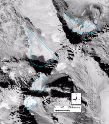
About 4 snow and ice bodies are found in the San Miguel Mountains, a subrange of the San Juan Mountains. Elevation ranges from 3887 m to 4236 m, with a mean of 4094 m, and a total area of 0.18 km2. There are no named features, and the only feature larger than 0.05 km2 is located between Mount Wilson and Gladstone Peak (0.94 km2). (Glacier outlines in San Miguel Mountains from USGS 1:24,000 scale topographic maps, created from 1952 aerial photographs) These features are all small, but exist at a wide range of orientations. The largest feature is somewhat unique in that it is on the west side of the main ridge. These features are the westernmost in Colorado. |
|
 Icefields in the San Miguel Mountains. Blue outlines are from 1952 topo map. Air photo is USGS September 9, 1998. Ice extent has not changed significantly. |
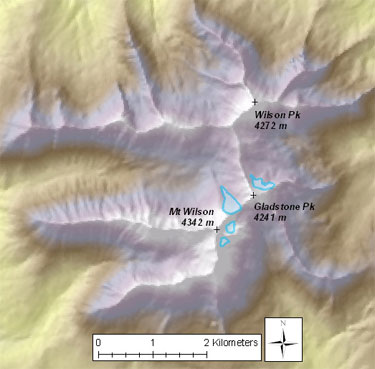 Glaciers and snowfields in the San Miguel Mountains shown in blue |
Back to Glaciated Regions of Colorado
Back to Contents
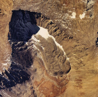
Sierra Blanca
|
Historically, two glaciers were identified in the Sierra Blanca in the southern Sangre de Cristo Range. C.E. Siebenthal described these features located on the north side of Blanca Peak in 1907: |
|
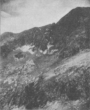 "Blanca glaciers" from the northeast in 1903 |
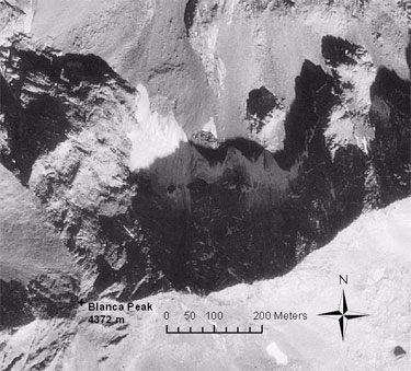 Aerial photo of "Blanca glaciers" (Photo: USGS 9/27/1998) |
Back to Glaciated Regions of Colorado
Back to Contents
Comparison Photos
|
Arapaho Glacier in 1898 (left, photo by R.S. Brackett, from NASA Earth Observatory) and in 2003 (right, photo by Tad Pfeffer; from NASA Earth Observatory) |
|
Tyndall Glacier in 1962 (left, from RMNP Archives) and in 2000 (right, from USGS) |


Fun Facts
|
Links
Bibliography
|
Buchholtz, C. W., 1983, Rocky Mountain National Park: A History. Colorado Associated University Press, Boulder, CO. 255 p. Comstock, T. B., 1886, Some Peculiarities of the Local Drift of the Rocky Mountains: American Naturalist, v. 20, no. 11, p. 925-927. Daly, C., Gibson, W., and and Taylor, G., 2003, United States Average Monthly or Annual Precipitation, 1971-2000: Digital Data from Spatial Climate Analysis Service at Oregon State University. Henderson, J., 1910, Extinct and Existing Glaciers of Colorado: University of Colorado Studies, v. 8, p. 33-76. Hills, R. C., 1884, Extinct glaciers of the San Juan Mountains: American Journal of Science, v. 27, no. 161, p. 391-396. Lee, C. M., Benedict, J. B., and Lee, J. B., 2006, Ice patches and remnant glaciers: Paleontological discoveries and archeological possibilities in the Colorado high country: Southwestern Lore Journal of Colorado Archaeology, v. 72, no. 1, p. 26-43. Lee, W. T., 1900, The glacier of Mount Arapahoe, Colorado: Journal of Geology, v. 8, p. 647-654. Madole, R. F., 1976, Glacial geology of the Front Range, Colorado, in Quaternary Stratigraphy of North America. Dowden Hutchinson & Ross, Stroudsburg PA. p. 297–318. Mills, E. A., 1905, The Story of Estes Park and a Guide Book. Outdoor Life Publishing Co., Denver, CO. 105 p. Russell, I. C., 1885, Existing glaciers of the United States. United States Government Print Office, Washington, D.C. 53 p. Siebenthal, C. E., 1907, Notes on glaciation in the Sangre de Cristo Range, Coloado: Journal of Geology, v. 15, no. 1, p. 15-22. Stone, G. H., 1887, A living glacier on Hague's Peak, Colorado: Science, v. 10, p. 153-154. |
Created by Matt Hoffman 2005-2009
Last updated 31 Aug 2011