Glaciers of California
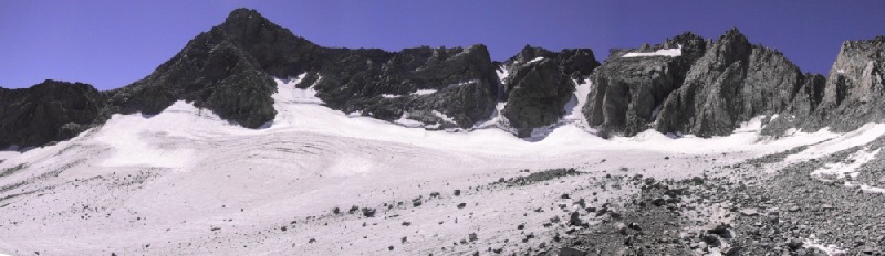
Palisade Glacier, Sierra Nevada, California (H. Basagic, 2003)
|
Welcome to the Glaciers of California page. This webpage contains information and pictures of glaciers in California. Glaciers of the past have played an important role in shaping parts of California's beautiful high country. Perhaps one of the best known of these locations is Yosemite Valley, in Yosemite National Park. Glaciers of today are much smaller as compared to those of the Pleistocene, but still play an important role in shaping the landscape. Additionally, the small glaciers are important to the hydrology of alpine ecosystems, and important indicators of climate change. |
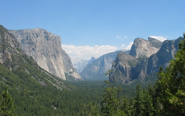 Yosemite Valley, Yosemite National Park (H. Basagic, 2004) |
Contents
Glacier Extent
 Blue Marble Imagery |
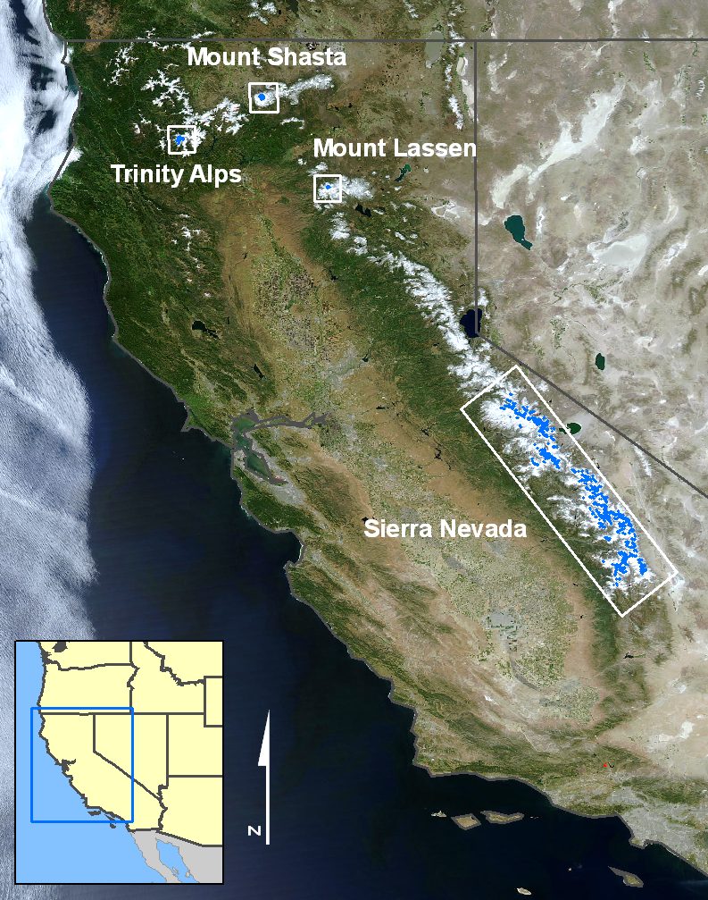
There are more than 1700 snow or ice bodies located in California (70 of these are larger than 0.1 km2). Twenty of these glaciers have been named - seven on Mount Shasta and 13 in the Sierra Nevada. Snow and ice bodies are also located in the Trinity Alps and near Mount Lassen. In total, permanent snow and ice bodies cover over 46 km2 of California. Note: These statistics are based on US Geological Survey (USGS) 1:24,000 topographic quadrangle maps. The maps were created from aerial photographs taken between 1956 and 1984 (Fountain et al., 2007). |
History
Glacial History
|
Glaciers have long played a role in the geologic history of California. In the past, glaciers were active in several areas of California, leaving behind geologic evidence such as glacial deposits, mountain cirques, and glacial striations. In northern California, evidence from glaciers during the Pleistocene is found at Mount Shasta, Lassen Volcano, throughout the Klamath Mountains, Medicine Lake Volcano, Salmon Mountains, Warner Mountains, and the Coast ranges. In central California evidence from glaciers can be found in the Sierra Nevada, White Mountains, and the Sweetwater Range. The only evidence of glaciation in southern California has been found in the San Bernardino Mountains (Sharp et al., 1959). During the cold Pleistocene epoch (Ice Age), which lasted between 1.8 million years ago to 10,000 years ago, glaciers fluctuated in size. Geologic evidence in the Sierra Nevada suggests at least five major glacial periods: McGee, Sherwin, Tahoe, Tioga, and Recess Peak (Bailey et al., 1990; Blackwelder, 1931; Clark and Gillespie, 1997). Similar evidence of glacier fluctuation is found in other regions of California. In the Holocene, the climate began to cool around 1350 A.D., during which time glaciers began to grow. This cool period, referred to as the Little Ice Age, persisted roughly through 1850 A.D., when glaciers are thought to have reached their maximum extent (Matthes, 1940). Since that time, mountain glaciers in California and throughout most of the world have showed signs of overall recession during the past century. |
Early Exploration
|
Glaciers were first "discovered" in the United States in California on Mount Shasta. Clarence King is accredited as the first person to publish a scientific account of the glaciers of Mount Shasta, based on his visit on September 11, 1870 (King, 1871). The existence of glaciers in the Sierra Nevada was identified shortly thereafter, in October, 1871, by the well-known naturalist John Muir (Muir, 1873). Muir had been tracing the routes of ancient glaciers in Yosemite National Park when he reached a cirque and proclaimed that he had found a "living glacier". Muir went on to count many more glaciers in his travels in the Sierra Nevada. |
|
|
One summer, Muir conducted glacier motion experiments on Maclure Glacier, also in Yosemite National Park, by placing stakes into the ice. Through these measurements, Muir confirmed that these ice bodies were indeed moving and therefore could be considered true glaciers (Muir, 1873). An expedition led by I.C. Russell, of the US Geological Survey produced photographs of Sierra glaciers in 1883, as well as the first map of Lyell Glacier (Russell, 1885). Russell's 1885 report also contained a map of the glaciers of Mount Shasta created by Gilbert Thompson. |
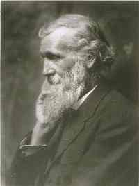 John Muir (Bancroft Library) |
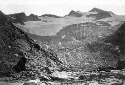 An early photograph of Lyell Glacier in 1883 (I.C. Russell, 1885) |
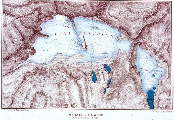 Map of Lyell Glacier in 1883 (I.C. Russell, 1885) |
 A photograph of Whitney Glacier taken during the 1876 King Survey (C.E. Watkins, 1876) |
|
Glaciated Regions
| Mount Shasta | Trinity Alps | Mount Lassen | Sierra Nevada |
Mount Shasta
|
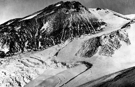
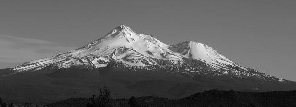
Mount Shasta is a stratovolcano located in northern California. There are 7 glaciers on the 4,317m (14,162 ft) peak: Whitney, Bolam, Hotlum, Konwakiton, Watkins, Mud Creek, and Wintun. Mount Shasta glaciers have a total area of 4.9 km2. |
 The north side of Mount Shasta (H. Basagic, June 2005) |
| The Whitney Glacier, located on the north side of Mount Shasta, is the longest glacier in California, and is over 3 km long with an area of 1.3 km2. In general, the glaciers on the north side of Mount Shasta are much larger than those on the south side. | |
Below is a map of Mount Shasta's glaciers. Click the map to enlarge the image.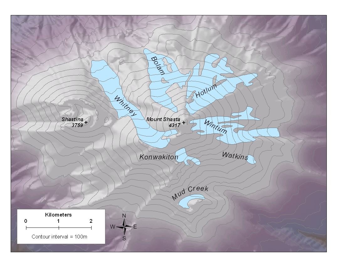 Map of Mount Shasta glaciers (Source: USGS 7.5 topographic map, photodate: 1980) For more information on Mount Shasta's glaciers you can visit the College of the Siskyous's Mount Shasta Companion Glacier Page. |
|
Trinity Alps
| There are several small glaciers located in cirques on the north sides of Thompson Peak (2742m, 8994 ft) and Caesar Peak (2720m, 8920 ft). The area contains over 35 other perennial snowfields. These perennial snowfields have a total area of 1.9 km2. None of these features have USGS names. |
|
|
Below is a map of Trinity Alp's perennial snowfields. Click the map to enlarge the image. Map of glaciers and perennial ice in the Trinity Alps (Source: USGS 7.5 topographic map, photodate: 1974) |
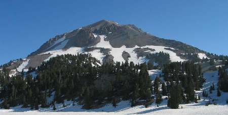
Mount Lassen
| Mount Lassen has 14 small snow and ice bodies. These features have a total area of ~0.2km2. The mountain does not have any named glaciers. |
Mount Lassen (H. Basagic, 2005) |
Sierra Nevada
|
This mountain range spans over 600 kilometers along the eastern California border. Glaciers are located in the central and southern portions of the Sierra Nevada. The USGS mapped over 800 small mountain glaciers and perennial ice fields with areas over 0.01km2, of which 13 are named. These small glaciers are located at high elevations (above 3050m) on the north and northeast sides of mountain cirques. The Palisade Glacier is the largest glacier in the Sierra Nevada, with an area of 0.8 km2. In contrast, the smallest named glacier is Lilliput Glacier, 0.05km2. |
|
 The view from Mount Darwin looking south at ice filled cirques in the Sierra Nevada (H. Basagic, 2003) |
|
| Palisade Glacier (right) is located on the east side of the Sierra crest. Glacier ice is indicated in light blue and the moraine-dammed lake is displayed in dark blue. Moraines, shown in brown, consist of rock material that have been transported to the glacier's edge through glacial movement. The glacier is about 1.3 kilometers in length, and terminates in the lake. | 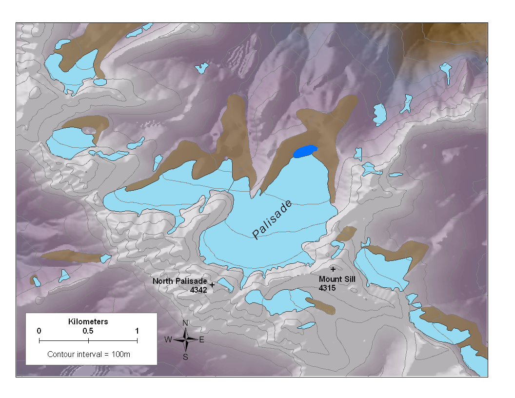 Map of Palisade Glacier, Sierra Nevada (Source: USGS 7.5 topographic map, 1976) |
|
Video of Palisade Glacier change since the Little Ice Age. (Gregory Ziolkowski) Palisade Glacier MS Thesis (2015) by Gregory Ziolkowski entitled "Retrieval of the climatic signal from the Palisade Glacier since the end of the Little Ice Age, Sierra Nevada, California" can be found here. |
|
| The most recent inventory of Sierra Nevada glaciers was done by Hassan Basagic, and can be found here. | |
Comparison Photos
|
Dana Glacier (unofficial name) in 1883 (left, photo by I.C. Russell, USGS) and in 2004 (right, photo by Hassan Basagic) |
|
Lyell Glacier in 1904 (left, YNP) and in 2003 (right, photo by Hassan Basagic) |
| A collection of additional Sierra Nevada comparison photos can be found here. |


Fun Facts
| California's state fossil is the sabertooth tiger (Smilodon fatalis).
The state insect is the California dog-face butterfly (Zerene eurydice). |
References
|
Bailey, R. A., Huber, N. K., and Curry, R. R., 1990, The Diamicton At Deadman Pass, Central Sierra-Nevada, California - a residual lag and colluvial deposit, not a 3-Ma glacial till.: Geological Society of America Bulletin, v. 102, no. 9, p. 1165-1173. Basagic, H.J., and Fountain, A.G., 2011, Quantifying 20th Century Glacier Change in the Sierra Nevada, California. Arctic, Antarctica and Alpine Research, 43(3): 317-330. Blackwelder, E., 1931, Pleistocene glaciation in the Sierra Nevada and Basin Ranges: Geologic Society of America Bulletin, v. 42, no. 4, p. 865-922. Clark, D. H., and Gillespie, A. R., 1997, Timing and significance of late-glacial and Holocene cirque glaciation in the Sierra Nevada, California: Quaternary International, v. 38-39, p. 21-38. Fountain, A. G., Hoffman, M., Jackson, K., Basagic, H. J., Nylen, T. H., and Percy, D., 2007, Digital outlines and topography of the glaciers of the American West: U.S. Geological Survey Open-File Report 2006-1340 p. 23 King, C., 1871, Active Glaciers within the United States: Atlantic Monthly, v. 27, p. 371-377. Matthes, F. E., 1940, Report of the Committee on Glaciers, 1939-40: Transactions American Geophysical Union, v. 1, no. 3, p. 396-406. Muir, J., 1873, On Actual Glaciers in California: American Journal of Science and Arts, v. 5, p. 69-71. Russell, I. C., 1885, Existing glaciers of the United States: USGS Annual Report 5, p. 303-355 Sharp, R. P., Allen, C. R., and Meier, M. F., 1959, Pleistocene Glaciers on Southern California Mountains: American Journal of Science, v. 257, no. 2, p. 81-94. Ziolkowski, G.C., 2015, Retrieval of the climatic signal from the Palisade Glacier since the end of the Little Ice Age, Sierra Nevada, California. M.A. California State University, Long Beach. 2015: 192 p. (pdf) |
Created by Hassan Basagic
Portland State
Last updated 24 Aug 2011